Content can be downloaded for non-commercial purposes, such as for personal use or in educational resources.
For commercial purposes please contact the copyright holder directly.
Read more about the The Creative Archive Licence.
Description
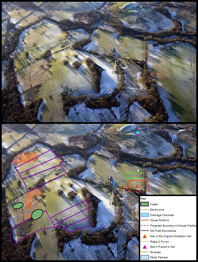
This is an aerial photograph looking West of Waun Las National Nature Reserve. At the top centre of the picture you can see the modern great glass house, in front of which once stood the second Middleton Hall that was built by Sir William Paxton in the 1790’s (Jones 2002). However the site of the original hall which was built 160 or so years prior to Paxton’s mansion is located to the east of the great glass house close to Waun Las Farm. The farm itself was built in the 1930’s by the local council who divided the estate into a series of small tenant farms which were occupied up until the late 1980’s (David et al 2011).
The location or rather the most likely location of the original Middleton Hall had been known for some years prior to the excavation in 2011. Within the planning stage of creating the botanic garden a series of surveys of the where conduced to assess the impact that the construction and maintenance of a botanic garden would have upon the archaeology and historic landscape (Austin & Dollery 2011). The first survey to formally acknowledge the earthworks within the vicinity of Waun Las was a report drafted for the Welsh Historic Gardens Trust in 1990. A brief survey of the earthworks was undertaken for the report in which the earthworks where described as being complex “but are evidence of an extensive settlement” (Gallagher 1990). The first archaeological survey within the estate was undertaken by Dyfed Archaeological Trust in 1996. The report was compiled by Neil Ludlow and assessed the impact upon the archaeology of the area due to the construction of the garden (Ludlow 1996). Within this report there is a brief mention of the earthworks within the field of Waun Las that had been identified and recorded within the sites and monuments record (SMR) and that the large earthwork platform was probably the site of the former mansion (ibid). It was not until 1999 however that the first comprehensive earthwork survey was undertaken by an MA student from the University of Wales, Lampeter; Edward Baker. Baker’s survey and analysis of some earthworks to the east of the Waun-Las farm house confirmed the presence of large archaeological remains that were probably associated with the original Middleton Hall and also identified some of the earthworks as remains of a possible formal garden (Baker 1999).
In the bottom photograph you can see annotations depicting the various earthworks and archaeological features that can be seen on the aerial photograph. In the centre of the photograph you can clearly see the earthworks associated with Middleton Hall. Firstly there is the large plateau which would have been the promontory or platform which the mansion would have been sited. From the size of this feature it is logical to deduce that the hall would have been very large, probably encompassing the majority of this platform (Austin & Dollery 2011). This can also be further backed up with the research that has been done assessing the historic records associated with the hall. For instance the Hearth Tax record of 1670 mentions a large dwelling that has 17 hearths; in comparison with the other dwellings recorded in Llanarthney the majority of which only have one or two hearths; which is undoubtedly referring to Middleton Hall (Dollery 2012). In front of the house platform there are a series of terraces which have to date been interpreted as formally arranged garden terraces which may have been in baroque style, the typical fashion of the period (Austin 1999). At the extremity of the terraces you can see a large rectangular depression with a circular lump or mound to the east. This feature is by the far most interesting as it is probably a large water feature that would have been the focal point of the formally arranged gardens (Austin 1999). At present it is not clear what the circular mound within this feature is, one theory is that it is an artificial island, another that it is the remains of a grand fountain. There are also a number of earthworks within this field that have not been annotated onto this map, for instance to the south of the water feature and terraces there are a series of earthworks that could be a possible water garden running the southern expanse of the mansion, as wells as possible smaller water features (Austin 2011). Also behind the hall platform you can see in the overgrowth of the field a system of boxes that show clearly with the vegetation growing in them. These features again could be associated with water features or possibly drainage (Austin 2011). To the south of the hall platform you can also see the remains of tree copses that were planted during the Paxton redesign of the landscape as well as old field boundaries and evidence of ridge and furrow pushing back the chronology of the landscape to the medieval period (Dollery 2012). The creation of the Paxton parkland has done much to preserve the archaeology within the estate which can be demonstrated by this aerial photograph with the time depth of archaeological features which can be observed, dating as far back as the medieval period right up to the present day (Austin 2012).
Austin, D. History & Context from the Later Middle Ages to the Present Day. In Austin, D [Ed] 2011 Paradise Lost In Search of a Garden before the Garden: Middleton Hall. Report of project conducted in 2011. Heritage Lottery Fund.
Austin, D. 1999 The Cultural Landscape of Middleton: Draft Proposal to the National Botanic Garden of Wales. University of Wales, Lampeter, unpublished.
Austin, D & Dollery, J. Location. In Austin, D [Ed] 2011 Paradise Lost In Search of a Garden before the Garden: Middleton Hall. Report of project conducted in 2011. Heritage Lottery Fund.
Austin, D. & Dollery, J. The Excavation. In Austin, D [Ed] 2011 Paradise Lost In Search of a Garden before the Garden: Middleton Hall. Report of project conducted in 2011. Heritage Lottery Fund.
Baker, E. 1999 Cultural Landscape Management: Work placement assignment, National Botanic Garden. University of Wales, Lampeter, unpublished.
David, R. Smith, S. Davies, S. History of Middleton Hall. In Austin, D. [Ed] 2011 Paradise Lost In Search of a Garden before the Garden: Middleton Hall. Report of project conducted in 2011. Heritage Lottery Fund.
Dollery, J. 2012 Paradise Rediscovered: Charting the rise and decline of a lost manorial centre in the historic parish of Llanarthney, Carmarthenshire. University of Wales, Trinity Saint David. Unpublished.
Gallagher, C. 1990 WNBG: Middleton Hall Landscape Survey. Debois Landscape Survey Group.
Jones, F. 2002 Treasury of Historic Carmarthenshire: The Dyfed Collection. Vol IV. Pembrokeshire: Bawdy Books ltd
Ludlow, N. D. 1996 Middleton Hall: Initial Assessment of the Archaeological Implications of the Proposed Botanic Garden. Dyfed Archaeological Trust. DAT Project Record 31018.


Do you have information to add to this item? Please leave a comment
Comments (0)
You must be logged in to leave a comment