Content can be downloaded for non-commercial purposes, such as for personal use or in educational resources.
For commercial purposes please contact the copyright holder directly.
Read more about the The Creative Archive Licence.


Description
Picture: 1
Tylorstown Tip, Rhondda Fach. View from tops
Tylorstown tip and tramway from Wattstown, 1971
Date: 1971
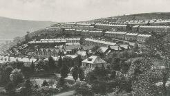
Picture: 2
Tylorstown Tip, Rhondda Fach. View from tops
Wattstown tip above Wattstown just South of Tylorstown. Ynyshir and Porth at junction of 2 Rhondda rivers
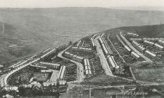
Picture: 3
Tylorstown Tip, Rhondda Fach. View from tops
View down Rhondda Fach to confluence with R. Fawr at Porth. Top right towards Tonyrefail is Rhiwgarn. Wattstown (left) Mid is Ynishir (Ynis is island, hir is something to do with water (?) between rivers
Do you have information to add to this item? Please leave a comment
Comments (1)
You must be logged in to leave a comment