Content can be downloaded for non-commercial purposes, such as for personal use or in educational resources.
For commercial purposes please contact the copyright holder directly.
Read more about the The Creative Archive Licence.

Description
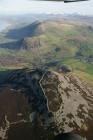
Slide of RCAHMW colour oblique aerial photograph of Caer Cadwgan, taken by T.G. Driver, 19/12/1999.
Caer Cadwgan is an oval enclosure, approximately 96m from north-east to south-west by 55m. It is defined by scree-like tumbled walls crowning a distinct hill above the Ffrwd Cynon valley. It also shows traces of a dividing wall, enclosing the higher, south-eastern part of the main enclosure. A less substantially defined outer circuit encloses an area about 60m across on the eastern and southern sides, with an entrance on the west, to the north of which is a possible oval banked and terraced enclosure, about 36m across, abutting the main circuit.
Excavations between 1984 and 1989 recorded details of a north-east facing entrance, subsequently blocked, and examined an area of the interior, with the remains of two circular structures, one of which was multiphase, its sequence interupted by a four-post structure. Occupation may have extended into the Roman period, with subsequent re-use (or continuing use).
Sources: Burnham in UWL Caer Cadwgan interim reports, 1984-9;
Austin et al. 1988 Current Arch. 109, 51-4;
Davies & Hogg 1994 'Cardigan. County Hist. I', 257-8 fig 53;
see also - AW 24 (1984), 26-8; AW 25 (1985), 18.
J.Wiles, RCAHMW, 31 January 2005.
The name Caer or Gaer Maurice appears on the Ordnance Survey 1st Series, dated 1834 and in "The History of Cardiganshire" by Samuel Rush Meyrick, (page 227).


Do you have information to add to this item? Please leave a comment
Comments (1)
You must be logged in to leave a comment